
Bald River Falls

Along the Cherohala

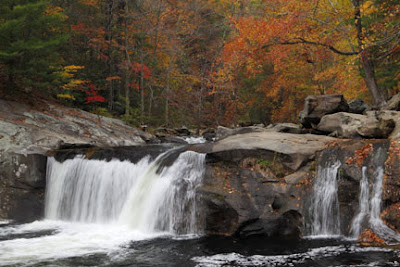
Bald River Gorge
This area adjoins Smoky Mountain National Park, by far the most visited National Park in the country. Because of this popularity photographers often find themselves in traffic jams and fighting each other for some of the more photogenic (and overshot) areas. The Cherohala Skyway area has many of the same opportunities but far fewer visitors. I did not see another tripod until the third day.
That does not mean, however, that you have the area completely to yourself. Sports car enthusiast and cyclists find the roads in the area very attractive and businesses cater to them. The most famous of these roads is The Dragon's Tail (http://www.tailofthedragon.com/ ) which boasts 318 curves in 11 miles. Traveling this paved road would not be the best choice for somebody susceptible to car sickness but for the lover of sports cars and fast cycles it is pure adrenaline. Several online photographers set up along the road and snap your picture as you cruise by. In a couple days you can find and order your picture. Since The Dragon's Tail is part of State Highway 129 the fast machines have to share the road and you may find your beat up Silverado being tailgated by a Ferrari or Viper. Sometimes tractor trailers use the road which can be dangerous since they have to use both lanes to navigate many of the curves. Meeting one of these on a cycle as they block the entire road is a cyclist's nightmare and hence the name "cycle eater".

Arriving back in Tellico Springs your choices at fine dining are somewhat limited but the Tellico Grains Bakery ( http://tellico-grains-bakery.com/ ) is a wonderful place for lunch if you can find a parking spot between the Corvettes and Vipers.

Coker Creek Falls
Baby Falls


